
Locks, weirs, barrages and storages
Locks, weirs, barrages, storages and other infrastructure (like environmental regulators) along the River Murray have been installed to manage flows to support navigation and irrigation, and to store water.
As in many rivers across the world, the structures were installed to control river flows, to maintain stable, safe water levels for boating and reliable water extraction. Controlling flows and water levels also helps us to support ecosystems along the river, Lower Lakes, Murray Mouth and Coorong.
There are 14 weirs along the River Murray. Lake Victoria, just above the South Australian border, is used to store and regulate flows into South Australia.
- Murray-Darling Basin locks and storages map
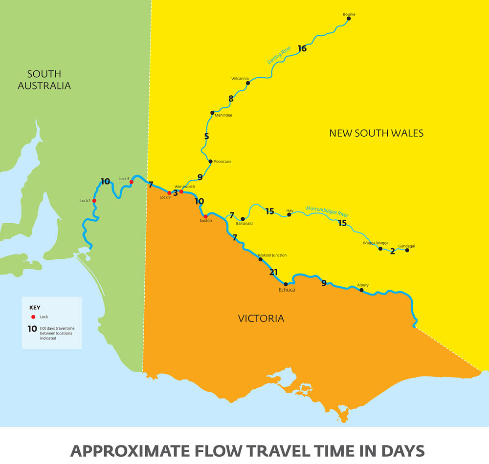
- Flow travel times across the basin
- River Murray floods FAQs: managing the Lower Lakes, barrages and Murray Mouth
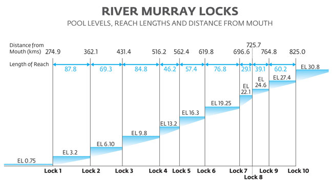
- River Murray lock pool levels, reach length and distance from Murray Mouth
River management
There are nine locks and weirs between Lake Victoria and the Murray Mouth which are operated by SA Water, six of which are in South Australia. They allow water to be stored during wetter times, so releases from dams and water levels along the river can be managed, and water can be delivered when and where it is needed.
The South Australian Government manages the river and regulating structures on a daily basis downstream of the South Australian border, with advice from the Murray-Darling Basin Authority on expected impacts of upstream operations.
It can take about two months for water to travel from the upper river to South Australia, which is an important consideration in managing the river, particularly during times of flood or drought.
The river, wetlands and floodplains
The River Murray is part of the Murray-Darling Basin, which drains about 14 per cent of Australia’s land area. Water from the Murrumbidgee and Darling rivers as well as a vast network of tributaries, creeks and watercourses all flow into the River Murray.
If not for the locks and other structures, flows down the River Murray would vary, with melting snows in the Australian Alps in spring producing higher flows than in summer when flows would be low. This variation - which is how the river would work if not for the structures - means wetlands and floodplains should, in natural conditions, experience wet and dry cycles between seasons and years. So, the structures now seriously impact on the ecosystems that rely on these cycles.
That's where river management comes in. By operating the weirs, barrages and environmental regulators, we can replicate a more natural variation in water levels. The weirs help to:
- store water and regulate river flow
- provide a higher river level to improve the river's navigability.
The locks allow boats and other vessels to travel through the weirs.
Weir pools are the water stored behind the weirs, and their water levels can be altered to help divert water for agricultural, town and industrial use.
Lock 3
Lock 3 controls 85 km of the River Murray and contains the most diverse range of flow conditions of all the weir pools in the South Australian River Murray. The Lock 3 Reach connects many significant water bodies, including Lake Bonney, Banrock Station and Wachtels Lagoon. It is also the heart of the major townships of Loxton and Barmera, which rely on this stretch of river for critical human water needs, irrigation, industry, recreation and tourism.
There has been significant infrastructure investment in the Lock 3 Reach to support River Murray environmental outcomes, namely at Pyap Lagoon, Yatco Lagoon and Beldora and Spectacle Lakes wetland complex, as well as recent investment on the Katarapko Floodplain.
Lock 6
The Lock 6 Reach spans from near Lake Victoria, NSW through to just upstream of Murtho in SA. It supplies water to the iconic Chowilla Creek and floodplain and is critical to the operations of the Chowilla environmental regulator. It is home to many iconic and endangered native species and is of significant cultural importance to the First Peoples of the River Murray and Mallee Region.
The Lower Lakes
Water quality and levels in Lake Alexandrina and Lake Albert depend on water flowing into them from the River Murray and out through the Goolwa Barrages. Wind plays a large part in transferring water between the lakes.
During low flows, the barrages can create a barrier to prevent seawater from entering the freshwater lakes. However, it is important that enough water flows out through the barrages to flush salt and other pollutants from the lakes.
Before the Millennium Drought, the lakes were maintained at a relatively stable water level. Now, we try to create more variable flows to support a healthier ecosystem, building ecosystem resilience to cope with dry times. It will also reduce the risk of exposed acid sulfate soils in future droughts.
The Murray Mouth
The Murray Mouth is the only site where salt, silt, nutrients and other contaminants can be flushed from the entire Murray-Darling Basin out to sea. Five barrages near Goolwa are used to coordinate releases of water to flush pollutants from the system and prevent sea water from entering the freshwater Lower Lakes during times of low river flows.
During dry times, if enough water does not flow out of the Murray Mouth to prevent silt building up, dredging may be needed to keep the mouth open and the river system connected to the ocean.
The Coorong
Flows through the Goolwa Barrages and Murray Mouth are critical for maintaining a healthy Coorong, as they influence salinity levels in the northern and southern lagoons.
When river flows through the barrages are high, freshwater enters the Northern Lagoon and freshens the Coorong. When flows are low, sea water enters the Northern Lagoon through the Murray Mouth.
Historically, freshwater from the south-east of South Australia played an important role in maintaining salinity levels in the Southern Lagoon. However, for many decades drainage schemes redirected this water to the sea so the land could be used for agriculture. This caused salinity in the Southern Lagoon to rise.
Without enough fresh water entering the Coorong via the barrages and South-East, evaporation concentrates the amount of salt in the lagoons and they can become too saline for many plants and animals to survive.
- Our water projects, past and present, working to improve the river, wetlands and floodplains.
- The Basin Plan, which manages constraints such as bridges or river practices that restrict the amount of water that can be delivered to floodplains, to allow higher flows down the river.

The barrages
To help keep salt water out of the lakes, there are five barrages near Goolwa.
Salt and other nutrients from the entire Murray-Darling system are normally naturally washed out to sea through the Murray Mouth. As a result of upstream extraction, lower river flows allowed increasing volumes of seawater to intrude into the freshwater lakes
Barrage and Water Level Management Policy
Under the Basin Plan and The Living Murray Program, more water is delivered to South Australia for our environment, which is great. But it also increases the complexity around managing water in the Coorong and Lower Lakes.
Using the best available research and knowledge on the Coorong, Lower Lakes and Murray Mouth and water level management, and extensive stakeholder engagement, we developed the:
- Barrage and Water Level Management Policy, which guide decisions on water level and barrage management and describes optimal water levels to get the best environmental, social, economic and water security outcomes, while managing risks and trade-offs
- Barrage Operating Strategy, which guides decisions on the operation of the barrages to achieve ecological outcomes for the Lower Lakes and Coorong. It includes management tools, rules and procedures operating the barrages under different conditions. The strategy provide formal decision-making processes for transparent and efficient barrage management.
These documents include valuable input by the Ngarrindjeri, the traditional owners of the area, and by other community groups and scientific advisors.
- More about the history and operations of Barrage Management on the Coorong and Lakes Ramsar Wetland Portal

Common questions about the barrages
How do we know the Lower Lakes were historically predominantly freshwater?
There is significant evidence.
- Ngarrindjeri traditional stories mention that the lakes were fresh. The plant and animal life that features in the stories are freshwater species. Ngarrindjeri were more or less permanently settled at the Lakes before European settlement, another indication that the lakes were freshwater.
- Overlanders bringing stock from NSW in 1839 to the eastern shores of the Lakes report “waters quite sweet and fresh”.
- Explorers such as Charles Sturt and various Surveyor Generals’ reported freshwater lakes. Settlers drew water for domestic and stock from the lakes in the 1800s, and a productive Murray Cod fishery existed in the lakes in the 1800s.
- An independent review of scientific studies about the Lower Lakes found they were largely freshwater prior to European settlement. It was informed by palaeoecological records, water balance estimates, hydrological and hydrodynamic modelling, traditional knowledge of the Ngarrindjeri People and anecdotal evidence of early explorers and colonists.
Why aren’t the barrages opened and seawater allowed to enter the Lower Lakes?
South Australia and the Australian Government would be contravening the Environment Protection and Biodiversity Conservation Act 1999 (Cwlth) and the Ramsar Convention if the barrages were fully opened.
Our priority is to ensure freshwater environments in the area are protected from seawater intrusions. When river levels are low, the barrages prevent seawater from destroying the region’s ecological character as a wetland of international importance.
Would there be water savings from opening the barrages?
Opening the barrages would require construction of a weir further upstream. A weir at Pomanda Island was investigated during the Millennium Drought as an option for maintaining water levels between Wellington and Lock 1. If such a weir were installed, a minimum through flow would be required to avoid major water quality issues upstream of the weir. It was found that the volume required would be sufficient to maintain suitable freshwater levels in the Lower Lakes, removing any necessity for a weir (or for the introduction of seawater).+
How did seawater enter the Lower Lakes?
As a result of upstream extraction, reduced river flows coming through the Murray Mouth allowed seawater to intrude into the freshwater Lake Alexandrina and Lake Albert. This threatened the natural habitat of many of the unique species in the region.
In 1931, the River Murray Commission at the time decided - after extensive investigation and instead of reducing upstream extractions - to construct five barrages to:
- manage lake levels to protect irrigation and river boat navigation
- improve water quality in the lower Murray and Lower Lakes system.
Work on the barrages commenced in 1935 and was completed in 1940.
Today, the barrages are used to manage water levels in the Lower Lakes and deliver freshwater to the Coorong and estuary.
